

 Phoenix 24
Power projection starts long before the first strike.
Brussels, March 2026
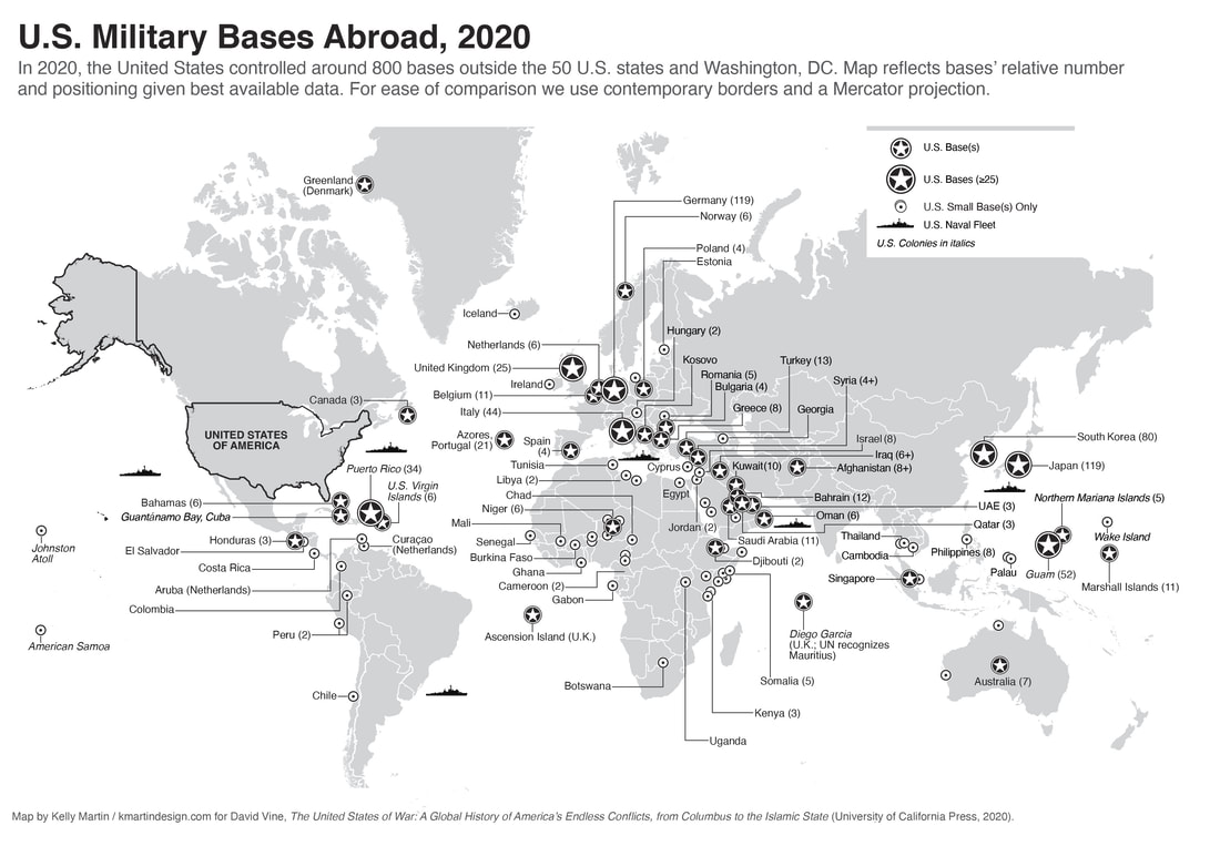
A map of U.S. military bases overseas may look like a reference tool in the middle of the Iran war escalation, but in practice it functions as a strategic decoder. What Euronews presents as a geographic overview is also a real time explanation of how Washington turns distance into reach, and why regional crises rapidly become alliance stress tests once basing access, overflight permissions, and host-country politics enter the equation. In moments of accelerated conflict, the map stops being descriptive. It becomes operational.
The immediate relevance is obvious. As the confrontation involving Iran widens, public attention is shifting from missiles and airstrikes to the infrastructure that makes sustained military action possible. Bases, ports, logistics hubs, and prepositioned assets are not secondary details in that system. They are the backbone of tempo. A campaign can be politically authorized in hours, but its durability depends on where aircraft can refuel, where munitions can be staged, where ships can rotate, and which governments continue allowing their territory to support the mission.
That is why this kind of mapping matters now. It clarifies a point often lost in public debate: U.S. global power is not only a matter of weapons, but of distributed agreements. Every overseas installation sits inside a political relationship with legal limits, domestic sensitivities, and changing strategic conditions. The same base that looks permanent on a map can become conditional in a crisis if the host state narrows permissions, imposes restrictions, or seeks distance from escalation. Geography, in other words, is never neutral. It is negotiated.
The current war cycle has made that reality visible at speed. Recent disputes over allied cooperation in Europe, including public friction over base access for operations linked to Iran, show that military architecture and diplomacy cannot be separated once conflict intensifies. A base is not just a runway or port facility. It is a sovereignty interface. It allows force projection only as long as host governments calculate that the strategic benefits outweigh domestic political cost, legal exposure, and retaliation risk.
A global map also reveals the layered design of U.S. posture. Some locations function as major command and logistics hubs, others as rotational platforms, intelligence nodes, naval support points, or rapid access sites. This matters because public narratives often treat “bases” as a single category when they are not. Their strategic value depends on mission type, theater proximity, storage capacity, interoperability with allies, and vulnerability to attack. In wartime planning, the difference between a symbolic presence and a high throughput operational hub can alter the entire campaign timeline.
The Middle East gives this logic its sharpest expression. Installations across the Gulf, the Eastern Mediterranean, and surrounding corridors are central not only for combat operations but for missile defense, surveillance, evacuation planning, and diplomatic signaling. Once Iran threatens retaliation against foreign participants or warns European states against entering the war, the map of bases becomes a map of potential pressure points. It shows where deterrence is projected, but also where escalation can be absorbed, contested, or politically constrained.
There is another reason this matters for Europe. The presence of U.S. military infrastructure on allied territory creates both reassurance and exposure. It strengthens deterrence and interoperability, but in a fast moving regional war it can also transform distant allies into logistical stakeholders in a conflict they may be trying to contain politically. That tension is now central to European crisis management. Governments are not only asking what they support in principle. They are being forced to decide what their territory enables in practice.
The map therefore carries an economic layer as well. Shipping insecurity in Hormuz, volatility in energy markets, and pressure on aviation routes do not unfold in isolation from military geography. They interact with it. The more a conflict depends on distributed basing networks, the more civilian systems, trade corridors, and diplomatic channels become entangled with military planning. In modern war, infrastructure categories blur quickly. Ports serve commerce and force posture. Airports move civilians and strategic assets. Logistics nodes become both lifelines and liabilities.
For Phoenix24, the key pattern is structural. A map of U.S. bases abroad is not merely an atlas of American presence. In periods of escalation, it becomes a map of negotiated power, alliance dependence, and potential friction zones. It shows how Washington projects force, but also where that projection can slow, fragment, or trigger backlash when host-country consent becomes uncertain. The headline may be about locations on a map. The deeper story is about how global military architecture translates into political leverage, operational endurance, and strategic vulnerability at the same time.
Geopolitics, unmasked. / Geopolitics, unmasked.