
When an island asks for military support, weather has already become system stress.
Las Palmas de Gran Canaria, March 2026.
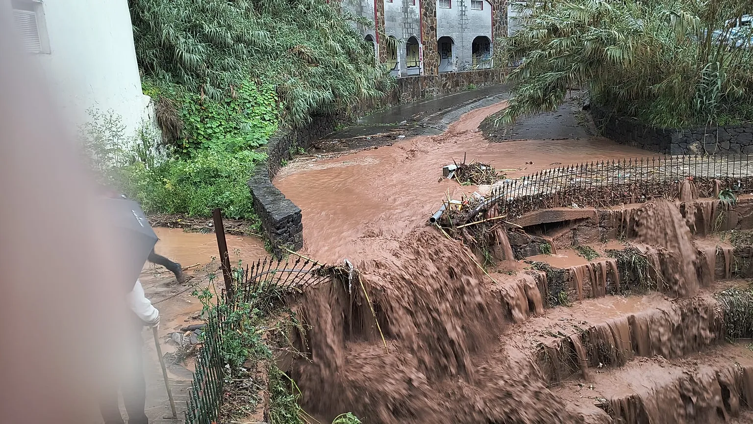
Gran Canaria has activated Level 2 of emergency response and requested support from Spain’s Military Emergency Unit after several days of intense rainfall pushed the island beyond the limits of an ordinary local contingency. The decision marks a shift in scale. What began as a severe weather event is now being treated as a broader operational crisis, one in which hydrological pressure, damaged mobility corridors and the strain on public response systems are converging at the same time.
That institutional escalation matters. Level 2 is not simply a louder warning. It is the language authorities use when the resources available under the previous phase are no longer enough for the size, persistence or complexity of the emergency. In practical terms, it means the island is no longer dealing only with rain, but with the cumulative impact of rain on roads, reservoirs, ravines, emergency access and civilian protection. A storm becomes more dangerous when it starts weakening the systems that are supposed to contain it.
The situation on Gran Canaria appears to reflect exactly that transition. After several consecutive days of impact from the same storm system, the problem is no longer defined only by the intensity of the precipitation, but by saturation. Water accumulates, runoff accelerates, terrain destabilizes and the margin for institutional error narrows. Roads close not as isolated incidents but as part of a chain reaction. Reservoirs and ravines become strategic points of concern. Public messaging has to do more than inform. It has to preserve order and reduce panic while conditions remain volatile.
What makes this episode especially serious is the multi-day nature of the pressure. A short burst of extreme weather can be destructive, but prolonged rainfall changes the structure of the emergency. It produces fatigue inside the response apparatus and uncertainty among the population. The island’s authorities are no longer reacting to one peak event. They are trying to manage a sequence of impacts that can move from one zone to another while the underlying infrastructure remains stressed. That is why requests for outside support often signal something deeper than meteorology. They suggest that local resilience is being tested in real time.
The hydrological dimension is central here. Once dams begin releasing water, ravines gain force and runoff intensifies near populated corridors, the emergency becomes territorial as much as climatic. The issue is not simply how much rain has fallen, but how the island absorbs it. In fragmented geography, especially on mountainous islands with vulnerable transport routes and uneven settlement patterns, extreme rainfall can rapidly expose the limits of administrative reach. Access becomes uncertain. Coordination becomes slower. Small failures begin to compound.
There is also a governance lesson hidden inside the weather narrative. Tourist territories often project continuity, stability and controlled infrastructure. But heavy rain has a way of stripping away that image and revealing the deeper architecture underneath. Roads, drainage, slopes, water management systems and emergency logistics suddenly become visible as political infrastructure. The real question is not whether the island can endure a storm in symbolic terms, but whether it can preserve operational coherence while multiple systems are stressed at once.
That is why the request for the Military Emergency Unit should be read carefully. It is not just a technical step. It is an acknowledgment that the crisis has exceeded the comfort zone of ordinary island management. Once military emergency support enters the picture, the state is no longer responding only to hazardous weather. It is trying to prevent overload from becoming disorder. That distinction matters because the most consequential disasters are often not defined by a single catastrophic image, but by cumulative institutional saturation.
Suspensions of in-person activities, transport adjustments and public warnings all reinforce the same pattern. The storm has moved beyond the environmental sphere and into the administrative core of daily life. Schools, mobility, safety messaging and territorial coordination are all being shaped by the same atmospheric event. That is when a climate emergency stops being episodic and starts revealing a wider vulnerability map.
Gran Canaria now enters the phase that is often harder than the peak itself. Even if rainfall begins to ease, saturated terrain, water releases, damaged routes and delayed restoration can prolong the instability. In many emergencies, the storm leaves before the crisis does. Recovery does not begin the moment the clouds thin out. It begins when institutions regain enough control to prevent the next incident from emerging out of the residue of the first.
What is unfolding on the island is therefore larger than a rain alert and more revealing than a temporary disruption. It is a reminder that climate pressure increasingly operates through accumulation. It does not always arrive as one dramatic collapse. Sometimes it advances through persistence, overload and the slow erosion of local capacity until a government has to admit, in formal terms, that routine response is no longer enough.
Más allá de la noticia, el patrón. / Beyond the news, the pattern.